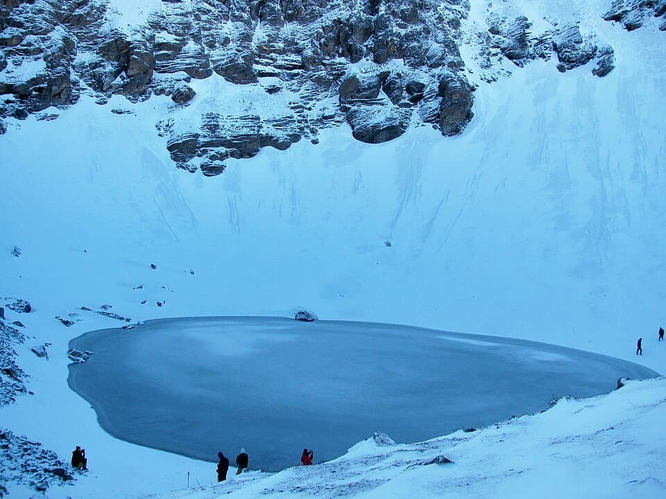
The lake is roughly 40 metres across. When it thaws in summer, somewhere between 800 and 1,200 human skeletons surface around the rim and just below the waterline. Carbon-dating places the oldest bones around 800-900 AD. A 2019 Harvard-led DNA study found that some remains carry Eastern Mediterranean ancestry - a finding that nobody has adequately explained. Were they pilgrims? A stranded army? Ritual deposits? Twenty years of academic papers and the answer is still genuinely unknown.
That mystery is real, and worth knowing. But it is not the reason Roopkund demands serious planning. The reason is the altitude. At 5,029m, the lake sits higher than any point in the Alps outside of Mont Blanc. The final 629m from Bhaguabasa base camp involves fixed ropes on rock and ice. If the weather turns - and at 4,400m it can turn inside 20 minutes - the exposure is severe. I have seen trekkers turn back at Bhaguabasa because their bodies simply would not cooperate above 4,000m after five days on the trail. That is not failure, it is good judgement.
This guide covers the 8-day route from Lohajung in the way I wish someone had laid it out for me: concrete distances, honest difficulty grading, permit logistics, cash planning, and the exact nature of that final ascent.
Getting from Dehradun to Lohajung (260 km, 8-9 hours)
Lohajung sits in Chamoli district at 2,270m. From Dehradun, the route runs: Rishikesh (60 km) - Devprayag - Srinagar Garhwal - Rudraprayag - Chamoli - Tharali - Mundoli - Lohajung. Total: approximately 260 km.
The Dehradun to Rishikesh leg takes about 1.5 hours by shared cab or bus from ISBT Dehradun. After Rishikesh, most trekkers take a private cab hire from Rishikesh to Lohajung, which runs Rs 4,500-6,000 depending on the vehicle. No direct buses serve Lohajung - you change at Tharali and find local transport for the last 25 km.
Key road note: the stretch from Tharali onwards is a mountain road with hairpin bends and narrow sections. It is fine in dry conditions. In wet weather, particularly June-July, landslide risk is real on the Chamoli-Tharali corridor. Check conditions if you are driving between July and August - also see the monsoon-routes guide before you plan this leg.
ATM situation: the last reliable ATM before Lohajung is at Tharali or Ghat, both on the main Badrinath highway. Lohajung village has no ATM. Carry a minimum of Rs 5,000-7,000 in cash before you leave Rishikesh. Full breakdown of cash logistics is in the atm-cash-guide.
What kind of trek this is
Difficulty: Hard. Not technical mountaineering - but hard trekking.
The standard classification puts Roopkund a notch above treks like Kedarnath (which is a pilgrimage trail, paved most of the way) and roughly comparable with Har Ki Dun at the top end for difficulty. Where Roopkund differs from Har Ki Dun is the final day: the Bhaguabasa to lake section involves a fixed-rope pitch of about 200m on mixed rock and ice or rock and scree depending on season. Most able-bodied people can manage it, but it requires using your hands, staying calm on the rope, and not having an acute altitude reaction at 4,800m while doing it.
Fitness baseline: you should be able to run 5 km without stopping and walk 15+ km in a day with a loaded pack (8-10 kg). Prior altitude experience above 3,500m is genuinely useful - not mandatory, but it makes you a better judge of your own body on Day 6 when things get serious. The acclimatize-above-3000m guide covers the physiology in detail.
This is not the right trek for complete beginners. Chopta at a maximum altitude of 3,680m is a better first Uttarakhand high-altitude experience.
8-day itinerary - Days 1-6 (drive + ascent to Bhaguabasa)
Day 1 - Dehradun to Lohajung (2,270m): drive day. Leave Dehradun by 6-7 AM to arrive Lohajung by 3-4 PM, giving time to sort permits and sleep early. The village has guesthouses in the Rs 400-800/night range. Eat a proper meal, do not drink alcohol, drink 3 litres of water. Your first night at 2,270m is mild acclimatization.
Day 2 - Lohajung to Didna Village (2,270m to 2,750m, 9 km, 3-4 hours): gradual forest trail with oak and rhododendron cover. The elevation gain is modest - 480m over 9 km - which makes this the easiest walking day. Didna is a small village with basic homestay accommodation (Rs 300-500 per bed with meals). Stock up on any supplies here - the trail gets more remote from this point.
Day 3 - Didna to Ali Bugyal (2,750m to 3,612m, 8 km, 5-6 hours): the climb you remember. The trail rises steeply through forest, then emerges above the treeline into Ali Bugyal - a high-altitude meadow that stretches for several kilometres with nothing blocking the view of Trishul (7,120m), Nanda Ghunti (6,309m), and on clear days, the Nanda Devi massif. This is the section that photographs well and the reason many trekkers come even without pushing to Roopkund. Camp here. Temperature at night: 0-5C in September-October, can drop below minus 5C in May.
Day 4 - Ali Bugyal to Bedni Bugyal (3,612m to 3,354m, 5 km, 2-3 hours): a short traverse across the meadow, descending slightly to Bedni Bugyal. The Bedni Kund lake sits here at 3,354m with a small temple at its edge. This is a rest and acclimatization day by design. Do not rush it. Walk slowly, drink water, eat whatever you can stomach. Your body is adjusting to sustained altitude and needs the time.
Day 5 - Bedni Bugyal to Patar Nachauni (3,354m to 3,800m, 5 km, 3-4 hours): mixed terrain - forest sections, ridge walking, some exposed sections. Patar Nachauni sits in a sheltered hollow. The scenery is less dramatic than the bugyals but this is an important altitude-building day. Camp here, sleep early.
Day 6 - Patar Nachauni to Bhaguabasa (3,800m to 4,400m, 4 km, 3-4 hours): short in distance, significant in consequence. Bhaguabasa is the last camp before the summit push - no tree cover, exposed to wind from all directions, loose rock that makes tent-pegging a creative exercise. The campsite is at 4,400m and the cold at this altitude is different from what you experienced lower down.
I arrived at Bhaguabasa at around 6 PM on an October evening. The wind was cutting in a way that makes you understand why people use the word raw for high-altitude cold - it bypasses your jacket and goes directly to your skin. My tent pegs would not hold in the loose scree, so I ran guy-ropes to the nearest large boulders instead. Ate half a meal, drank two litres of water (force yourself), and was in my sleeping bag by 8 PM trying to sleep before the 3:30 AM alarm.
Day 7 - the summit push to Roopkund (5,029m)
This is the day the trek is named for.
Start time: 3-4 AM. The reason is weather, not scenery. Afternoons at 5,000m bring cloud, wind, and rapidly deteriorating visibility. You want to summit before noon.
The route: from Bhaguabasa, the trail climbs steeply over loose moraine for the first section, then hits the fixed-rope pitch - a roughly 200m section of mixed rock with occasional ice depending on season. In May-June, this section carries significant snow and you may need microspikes or crampons. In September-October, it is mostly dry rock with fixed rope as a handhold and safety measure.
The 35 minutes I spent on that rope section at 4,800m are lodged clearly in my memory. At altitude, simple physical tasks require concentration that flatland exercise does not prepare you for. You move deliberately. You check your grip. The exposure - a steep drop below the rope - is real.
At the top, the lake is smaller than photos suggest. Approximately 40m across, surrounded by steep rock walls. In September, the edges hold ice from the previous winter while the centre is open water. The skeletons are visible around the rim - partially submerged, partially exposed depending on the water level that season. Three skulls were clearly visible at one end when I reached the top, protruding from the ice line. Standing at 5,029m, breathing hard, looking at bones that are 900-1,200 years old and still have no definitive explanation for being there - it is a genuinely strange experience. Not frightening, but strange.
After the summit: descend to Bhaguabasa, collect your packed camp, and continue down to Bedni Bugyal (6 km). Total Day 7 movement: approximately 14 km with 629m gain and 1,675m descent. A long, physically hard day.
Day 8 - Bedni Bugyal to Lohajung (13 km, 5-6 hours): the long walk out. Mostly downhill, on familiar trail. Your knees will register the accumulated descent by mid-morning. Trekking poles help significantly. Arrive Lohajung by early afternoon, arrange transport back to Rishikesh or Dehradun.
Permits
Three things to sort at Lohajung before Day 2.
Forest Department permit: issued at the Lohajung forest office. The fee is approximately Rs 150-300 per person per day - confirm the current rate when you register, as it has changed year to year. You must register here regardless of whether you are on an organised tour or going independent.
Nanda Devi Biosphere Reserve permit: the Nanda Devi Biosphere Reserve covers parts of this route. Whether a separate biosphere permit is required depends on which specific zones the route passes through in a given season - the forest office at Lohajung will confirm. Do not assume you do not need it - check at registration.
IMF registration: the Indian Mountaineering Foundation maintains records for high-altitude treks. For Roopkund, formal IMF registration is not mandatory the way it is for technical peaks, but checking their current advisories is worth doing, particularly for May-June when snow conditions vary year to year.
Uttarakhand Forest Department portal: for pre-trek information on permits and forest zone regulations, the Uttarakhand Forest Department (forests.uk.gov.in) maintains updated guidelines on restricted zones and seasonal closures.
Best season for Roopkund
May-June: snow remains on the trail from Patar Nachauni upwards. The fixed-rope section near Roopkund may require microspikes or basic crampons. Fewer trekkers. The lake is typically still partially or fully frozen. Visibility of skeletons is reduced when the lake is iced over.
July-August: monsoon. The trail from Didna onwards becomes slippery clay. Landslides are a real risk on the Chamoli road. The meadows at Ali and Bedni Bugyal are green but the overall risk-reward is poor. I do not recommend this window unless you are experienced in monsoon mountain travel.
September-October: the recommended window. Trail is dry, the lake is fully or partially open (skeletons visible), weather is stable, views are clear. October temperatures at Bhaguabasa will hit minus 10-15C at night - this is manageable with proper gear, but not trivial. Refer to sleeping-bags-spiti for specifics.
November onward: trail is closing or closed. Snow accumulates rapidly above 3,500m and the route becomes a mountaineering objective, not a trek.
Gear you actually need
Roopkund's cold is the primary gear challenge, not the terrain. The final camp at 4,400m with wind chill can reach minus 15-20C on bad nights even in October.
The non-negotiables: sleeping bag rated to minus 10C or lower. A 3-season bag is insufficient for Bhaguabasa. See sleeping-bags-spiti for tested options. Insulated jacket - down or synthetic, minimum 600-fill if down. See jackets-kedarnath-trek. Base layer set - merino or synthetic thermals for top and bottom, one set minimum, two sets preferred for an 8-day trip. See thermals-high-altitude. Trekking boots - fully waterproof, ankle support, crampon-compatible if you are going in May-June. See trekking-shoes-under-5000. Backpack - 55-65 litre for independent trekkers, 35-45 litre if an operator carries the bulk load. See backpacks-chopta-tungnath. Headlamp - essential for the 3:30 AM start on Day 7. See headlamps-under-1000. Rain gear - even in the best-season window, afternoon showers occur at altitude. See rain-ponchos-char-dham. Power bank - no charging points from Didna onwards. An 8-day trek with a camera and phone requires at minimum a 20,000 mAh power bank. See power-banks-trek.
For the complete packing list framework, see packing-4000m.
Ali Bugyal and Bedni Bugyal - worth the trek alone
A significant portion of people who do the Roopkund route do not summit. They reach the bugyals, understand their body's limits, and turn back - and they still consider it one of their better trekking experiences.
Ali Bugyal sits at 3,612m and stretches for 3-4 km across open meadow with almost no obstruction. On a clear day the views include Trishul (7,120m) to the north and Nanda Ghunti (6,309m) to the northeast - these are serious Himalayan peaks visible at close range from a walking trail. The meadow is genuinely rare in how much sky it exposes.
Bedni Bugyal at 3,354m has the small temple complex at Bedni Kund and a reflective lake that, in September, mirrors the peaks above. If you compare this route to Chopta - another bugyal-based Uttarakhand trek - the scale here is considerably larger.
Neither bugyal is a consolation prize. They are the main event for many trekkers and there is nothing wrong with treating them that way.
Food, accommodation, and cost
Accommodation style: from Lohajung to Didna, guesthouses and homestays exist. From Didna upwards, you are camping - either in operator-supplied tents or your own. No guesthouse accommodation above Didna.
Food on the trail: operators provide all meals. Independent trekkers carry dry rations - instant noodles, nuts, energy bars, glucose biscuits - and supplement with whatever the rare tea shop along the route offers (expect basic dal-rice at a few stops, nothing beyond Patar Nachauni).
Operator cost: a fully guided 8-day Roopkund package from an established Uttarakhand operator runs Rs 12,000-20,000 per person depending on group size and services. Solo independent trekking is possible and considerably cheaper but requires good fitness, navigation ability, and self-sufficiency above Didna.
Rough independent cost breakdown: Dehradun to Lohajung (cab share or private) Rs 800-1,500. Lohajung accommodation 1 night Rs 500-800. Permits Rs 1,500-2,500 total estimated. Food and supplies 8 days Rs 2,000-3,000. Return transport Rs 800-1,500. Total independent estimate Rs 6,000-10,000 excluding gear.
Practical checklist before you leave Dehradun: Cash minimum Rs 5,000 withdrawn before leaving Rishikesh. Permits (Forest Department + Nanda Devi Biosphere). Sleeping bag rated to minus 10C or lower. Layers (base, mid, insulated, rain). Crampons or microspikes if May-June. Power bank 20,000 mAh. Pulse oximeter for altitude monitoring from Day 3 onwards. Headlamp + spare batteries for 3:30 AM Day 7 start. Register at forest office Day 1 evening in Lohajung - do not leave this for Day 2 morning.
When to go
What to pack
A full packing checklist is available to tick off and share. Start with these essentials, then adjust for the current forecast, route and your own needs: