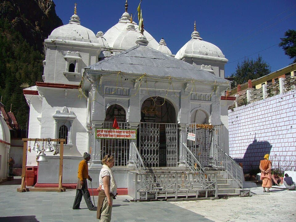
Gangotri is two separate experiences that happen to share the same name and the same parking lot. One is a pilgrimage: you drive to 3,048m, visit the temple on the right bank of the Bhagirathi, attend the evening aarti, and leave the next morning. The other is a trek: you walk 19 km up the Gangotri gorge to Gaumukh glacier at 3,892m, the actual source of the Ganga. The pilgrimage takes one day. The trek takes two.
Most people who visit Gangotri do only the pilgrimage. Most people who do the Gaumukh trek have never been inside the temple. Very few do both, which is a mistake - if you are already at 3,048m after an 8-hour drive from Dehradun, spending two extra days at Bhojbas and Gaumukh is worth the effort.
The confusion starts on the road from Dehradun. Gangotri is 248 km from the city I am based in, and the drive takes 8-9 hours with stops. I have done it in a single push leaving at 4 AM, arriving by 12:30 PM - barely enough time to check in, eat, and reach the temple before the afternoon break. Next time I will stop in Uttarkashi overnight. The road teaches you patience, and Uttarkashi makes a decent base for doing just that.
Gangotri in the Char Dham sequence
Gangotri is the third stop in the traditional Char Dham circuit, after Yamunotri and Kedarnath, and before Badrinath. Most pilgrims doing all four in a single yatra complete the circuit in 10-12 days from Haridwar or Rishikesh.
The four dhams at a glance: Yamunotri at 3,291m, 225 km from Rishikesh, opens Akshaya Tritiya, 6 km trek from Janki Chatti, source of the Yamuna. Gangotri at 3,048m, 250 km from Rishikesh, opens Akshaya Tritiya, drive to temple, Gaumukh glacier trek 19 km further. Kedarnath at 3,583m, 229 km to Sonprayag + 16 km trek, opens 2 weeks after Akshaya Tritiya, trek-only access, 12th Jyotirlinga. Badrinath at 3,133m, 295 km from Rishikesh, opens late April/early May, drive to temple, Mana village (last Indian village) 3 km beyond.
Gangotri is the only Char Dham temple that doubles as a serious trekking base. Yamunotri has a short approach trek, Kedarnath has a 16 km trek to the temple itself, but Gaumukh is a different category: a two-day glacier trek through a national park, with altitude gain, permit limits, and terrain that demands actual trekking gear.
Getting to Gangotri from Dehradun - the 248 km road
Route follows NH-94 to Rishikesh, then NH-108 (old NH-94) through Devprayag, Tehri, and Uttarkashi to Gangotri.
Segment breakdown: Dehradun to Rishikesh 42 km (1 hour, expressway most of the way, tolls at Mohand). Rishikesh to Devprayag 72 km (2 hrs, NH-94 along the Ganga, road is good). Devprayag to Tehri 28 km (1 hour, confluence stop worth 20 minutes). Tehri to Uttarkashi 79 km (2.5 hrs, dam reservoir crossing, road narrows after Chamba). Uttarkashi to Bhatwari 50 km (1.5 hrs, last proper fuel stop before Gangotri). Bhatwari to Harsil 23 km (1 hour, landslide-prone in monsoon). Harsil to Gangotri 27 km (1 hour, final climb, road narrows significantly). Total: 248 km, 8-9 hours.
Devprayag is worth a stop. This is where the Bhagirathi (coming from Gangotri) and the Alaknanda (coming from Badrinath) meet to become the Ganga. The confluence is visible from the road and from a short walk down to the sangam. I stopped here for 20 minutes on my last drive and ended up staying 45 minutes: the green Bhagirathi and grey Alaknanda run side by side for nearly 1 km before the colors finally blend.
Uttarkashi (174 km from Dehradun) is the logical overnight stop if you want to break the drive. SBI and Axis Bank ATMs, fuel stations, medical shops, hotels Rs 800-2,500. This is the last place to withdraw cash before Gangotri. The ATM at Gangotri is frequently out of service or out of cash. Carry at least Rs 3,000-4,000 in cash from here.
Road conditions Uttarkashi to Gangotri: mix of BRO-maintained and state PWD sections. Bhatwari to Harsil section is prone to landslides in July-August. Check uttarakhandroads.gov.in before traveling.
Leave Dehradun before 5 AM if you want to reach Gangotri before 1 PM. I left at 4 AM on my May drive and arrived at 12:30 PM. Traffic at Rishikesh and the narrow sections after Chamba eat time you do not see coming on the map.
The Char Dham e-pass and registration
Gangotri is covered under the Char Dham registration system. Vehicle permits (e-passes) are required during peak season to control traffic on the narrow mountain roads. Registration is done online at registrationandtouristcare.uk.gov.in before you leave Rishikesh.
The e-pass is vehicle-specific and checks are done at entry points along the route. Without it, you can be turned back at checkposts near Uttarkashi or Harsil. The permit process, timing of registration windows, and what to do if the portal is down are all covered in the char-dham-epass-permits guide.
The vehicle e-pass and tourist registration are separate from the Gaumukh trek permit. The Char Dham registration covers your pilgrimage registration and vehicle access. The Gaumukh permit is issued separately by Gangotri National Park. You need both if you are doing the trek.
Gangotri temple - what it is and what to expect
The Gangotri temple sits on the right bank of the Bhagirathi River at 3,048m. Dedicated to Goddess Ganga - this is where the river is worshipped as a deity, not the source of the river (that distinction belongs to Gaumukh, 19 km further up). The idol is a silver image of the goddess. The temple itself is a white granite structure, relatively modest in scale, built in the 18th century by Amar Singh Thapa of the Gorkha army.
The town around the temple is small: a cluster of dharamshalas, tea shops, a GMVN guesthouse, and the forestry department office where Gaumukh trek permits are issued. There is no bank branch. There is one small medical clinic. The road ends at a large parking area below the temple.
Temple timings (2026 season): morning opening 6:15 AM, afternoon break 2:00 PM, afternoon reopening 3:00 PM, evening closing 9:30 PM. Timings shift slightly by month - earlier closing in October as days shorten. Confirm with the temple trust on arrival or at uttarakhandtourism.gov.in. The morning session (6:15 AM to 2 PM) is the main one - if you are arriving from Uttarkashi in the morning, target reaching Gangotri by 10 AM to have comfortable time before the afternoon break.
The evening aarti at the riverbank is a separate ritual from temple darshan. Happens on the banks of the Bhagirathi at around 6-7 PM (exact timing varies seasonally). This is not a large-scale production like the Haridwar Ganga Aarti - it is quieter, attended by a few dozen people, and the sound of the river underneath the chanting is what stays with you afterward.
Accommodation: GMVN Guesthouse Rs 1,200-2,500 (book at gmvnl.com, limited rooms). Dharamshalas Rs 200-600/night (basic, no attached bathroom usually). Private lodges Rs 800-1,500/night (several options near parking area). Tented camps (private) Rs 600-1,000 (seasonal, near the riverbank). The GMVN guesthouse is the most reliable option for a hot shower and a proper bed.
The Gaumukh glacier trek - full breakdown
This is where Gangotri becomes a different kind of destination. The Gaumukh trek follows the Gangotri gorge from the temple at 3,048m to the glacier snout at 3,892m - a 19 km one-way walk through Gangotri National Park, past Bhojpatra forests and moraines, ending at the ice cave from which the Bhagirathi emerges.
Most people have been sold a moderate 2-day hike description. It is moderate in the sense that it is not a technical climb. But the altitude gain (844m over 19 km), the loose terrain on the final approach to Gaumukh, and the cold at night (even in May, Bhojbas drops to -3C after 10 PM) require preparation that many pilgrimage-focused visitors do not have.
Trek route: Gangotri to Chirbasa 9 km (3,048m to 3,600m, 3-4 hours, well-marked trail, enters forest). Chirbasa to Bhojbas 5 km (3,600m to 3,775m, 1.5-2 hours, Bhojpatra/birch forest thins out). Bhojbas to Gaumukh 5 km (3,775m to 3,892m, 1.5-2 hours, rocky moraine, glacier visible). Total one way: 19 km, 5-6 hours. Return Gaumukh to Gangotri: 19 km, 4 hours (faster downhill).
Bhojbas (3,775m) at the 14 km mark is where most trekkers spend the night. GMVN maintains a camp here with basic tents and a dining tent. Private tent operators also set up during season. Expect Rs 600-1,200 for a tent night with meals at Bhojbas. No proper building here - it is a flat area just above the treeline with mountain views on three sides.
I overnighted at Bhojbas in May. Left Gangotri at 7 AM, reached Bhojbas by 1 PM, had lunch and slept for two hours, then walked to Gaumukh (2 hours return) in the afternoon. Temperature at Bhojbas was fine during the day - 12C in sunlight - but dropped to -3C by 10 PM despite mid-May. My sleeping bag rated to 0C was not enough. Borrow or rent a warmer bag if you are going in May or October.
The Bhojpatra forests: between 3,500m and 3,800m the trail passes through Himalayan birch forests. Ancient-feeling trees with paper-white bark that peels in thin sheets. Bhojpatra bark was used as writing material in ancient India - Buddhist and Hindu manuscripts were written on it. In October, the leaves turn yellow and the forest becomes one of the better things on the entire Char Dham trail system.
Gaumukh means cow's mouth in Hindi - the glacier snout is named for the vague arch of ice from which the Bhagirathi River emerges. The actual snout location changes year to year as the glacier retreats. Between 1935 and 2023, Gangotri glacier retreated approximately 2.2 km. The ice front you see today is not where it was when your parents visited in the 1990s.
Beyond Gaumukh - Tapovan (4,463m): high-altitude meadow 5 km beyond Gaumukh, base camp for expeditions to Shivling (6,543m) and Meru (6,660m). The terrain between Gaumukh and Tapovan crosses the glacier itself in sections - route-finding without a guide is difficult. Hire a local guide at Gangotri (Rs 1,200-1,800/day). Do not attempt it solo on a first visit.
Gaumukh trek permit - how it works
The Gangotri National Park permit is mandatory for the Gaumukh trek. Only 150 permits are issued per day, total. During peak season (last week of May, early October), permits can run out by 9 AM. Get yours the evening before you plan to trek, not the morning of.
Where: Gangotri National Park Forest Department office, located near the main parking area at Gangotri.
Cost: Rs 150 per person per day (Indian nationals). Additional Rs 150 for overnight stay at Bhojbas (camp permit).
Documents needed: government ID (Aadhaar, voter card, or passport). One photocopy. The office makes photocopies but having your own is faster.
Hours: the office opens at around 7 AM. The trail gate opens at 6 AM - you technically need the permit in hand before the gate. In practice, the gate is sometimes unmanned early. Do not rely on this. Get the permit the evening before.
What to carry for the Gaumukh trek
Standard kit for a two-day Gaumukh trek:
Essential: trekking shoes with ankle support (not running shoes). Warm layer for evening and morning - a down or synthetic insulated jacket is not optional at 3,775m overnight. Thermal base layer. Rain poncho or waterproof shell - weather changes fast in the gorge, especially after noon. Headlamp for pre-dawn starts and camp use. Daypack 25-35 litre. Water bottle 2 litres minimum (refill at Chirbasa tea stall). Sunscreen SPF 50+ - UV at 3,800m is significant even on cloudy days. Rs 1,500-2,000 in cash for permit, tea stalls, and Bhojbas meals.
For the overnight: sleeping bag rated to -5C (or rent a warmer one at Gangotri, Rs 150-300/night). Light camp sandals for evening at Bhojbas. Personal medications, including altitude sickness tablets if recommended by your doctor.
See the packing-4000m guide for a complete checklist with weights and alternatives. See the trekking-shoes-under-5000, jackets-kedarnath-trek, thermals-high-altitude, rain-ponchos-char-dham, headlamps-under-1000, and backpacks-chopta-tungnath gear pages for specific recommendations.
When to go - month by month
April: closed (opens late April). Skip.
May (Akshaya Tritiya opening): 10-20C day, 0-5C night. Good window, crowded at temple opening.
June: 12-18C day, 2-6C night. Good, pre-monsoon crowds.
July: 12-18C day, 5-10C night. Heavy rain, landslide risk on road. Risky for the trek.
August: same as July - avoid unless flexible. Trail visibility at the glacier is often poor and moraine sections become slippery.
September: 8-15C day, 0-4C night. Best month overall - monsoon clears, trail dries quickly.
October (closes at Diwali): 5-12C day, -5 to 0C night. Cold but clear, Bhojpatra turns golden. Excellent for the trek.
November+: closed. Skip.
September and October are the correct months. The monsoon has cleared, the trail is dry, the Bhojpatra forest is turning color in October, and the glacier views are unobstructed. The trade-off is colder nights - plan for sub-zero at Bhojbas in October.
May-June is the second-best window and the one most people use because of the temple opening. The weather is reasonably stable until mid-June, when the pre-monsoon clouds start building.
The acclimatize-above-3000m guide is worth reading regardless of when you go - Gangotri's altitude affects more visitors than they expect, and altitude sickness at 3,048m is not rare.
Pilgrimage logistics - the one-day Gangotri visit
If you are doing the Char Dham circuit and Gangotri is one stop of four, here is the efficient version:
Day 1: Rishikesh or Uttarkashi to Gangotri. Arrive before noon. Check in, eat. Temple visit in the afternoon session (3 PM - 9:30 PM). Evening aarti on the riverbank around 6-7 PM.
Day 2: Early morning temple darshan (6:15 AM opening is the best slot, before crowds build). Leave Gangotri by 9 AM. Drive to Kedarnath start point (via Uttarkashi, Tehri, Rudraprayag to Sonprayag) - approximately 240 km, 8-9 hours. Start Kedarnath trek from Sonprayag/Gaurikund the next morning.
The Char Dham sequence (Yamunotri-Gangotri-Kedarnath-Badrinath) involves significant backtracking on this route because Gangotri and Kedarnath are on different valleys. Most pilgrims cover 1,000-1,200 km of driving for the full circuit. Time that reality into your planning.
When to go
What to pack
A full packing checklist is available to tick off and share. Start with these essentials, then adjust for the current forecast, route and your own needs: